A New Journey Begins
My final year at Lewis & Clark College brought a new set of challenges, namely my thesis research.
Built on a solid foundation of my concentration of studies in salmon and watershed conservation, I embarked on an academic journey of a magnitude second only to my degree itself. At the heart of my project lies the question:
How can public lands remain in public hands?
Attitudes toward public lands ebb and flow over time, but if Oregonians are to keep the Elliott State Forest in public hands, we must transfer ownership to the federal land management agencies.
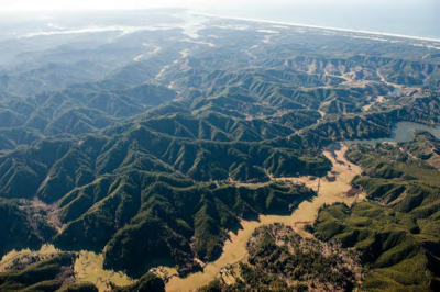
Aerial view of the Elliott State Forest, Source: Realty Marketing/Northwest, Jan. 2014
The transfer of the Elliott State Forest from state to federal ownership presents the most balanced array of long-term benefits for the various interests vested in this public land and sets a precedent for Oregon in the face of shifting U.S. national policy towards public lands.
Framing Question
How can public lands remain in public hands?
Focus/Research Question
What is the best option the state of Oregon has to maintain the Elliott State Forest's economic obligations to the Common School Fund while adhering to conservation mandates by the federal government and balancing public interests?
The public land ideology stretches far back into humanity’s history. The diverse policies that we use to establish public and private land ownership, not to mention their real-world results, are astoundingly complex and give rise to much conflict. Within the context of the recent Elliott State Forest controversy in central Oregon, an array of management options for this public land have been extensively investigated; out of these options however, the transfer of the Elliott State Forest from state to federal ownership presents the most balanced array of long-term benefits to the various interests invested in this forest and sets a precedent for the state in the face of shifting U.S. national policy towards public lands.
On a broader scale, I ask in the face of global public land grabs by private entities: how can public lands remain in public hands? International cases of attempted public land grabs have encountered substantial opposition, most often by the public themselves (the theoretical owners of the land). The sale of portions of the Karura National Forest in Kenya for instance, led to an unprecedented level of nationwide public outcry against government corruption (Klopp, 2000). In the United States, recent efforts by primarily Republican lawmakers attempt to transfer federal lands to state ownership, a move that often results in the sale of the land parcel to private entities (Jakus et al., 2017). In both examples, public outcry is a common thread, alluding to a high perceived value of public land. However, this sentiment has not always held true over time and geography.
Public land grabs by private entities (and in the international realm, by countries) are modern controversial issues that call into question the opportunity costs of keeping public land in public hands. Most often, public land regimes provide economic (selective cutting forestry, mining, tourism, etc.), social (outdoor recreational activities, nature therapy, etc.), and environmental benefits (carbon sequestration, water purification, etc.) in the long-term as opposed to private land, which typically harbor immense short-term benefits more skewed towards one or two of these factors (Krutilla et al., 1983) The action of the state to designate public ownership to a parcel of land is then a deliberate move to prioritize long-term economic, social, and environmental benefits over short-term economic benefits.
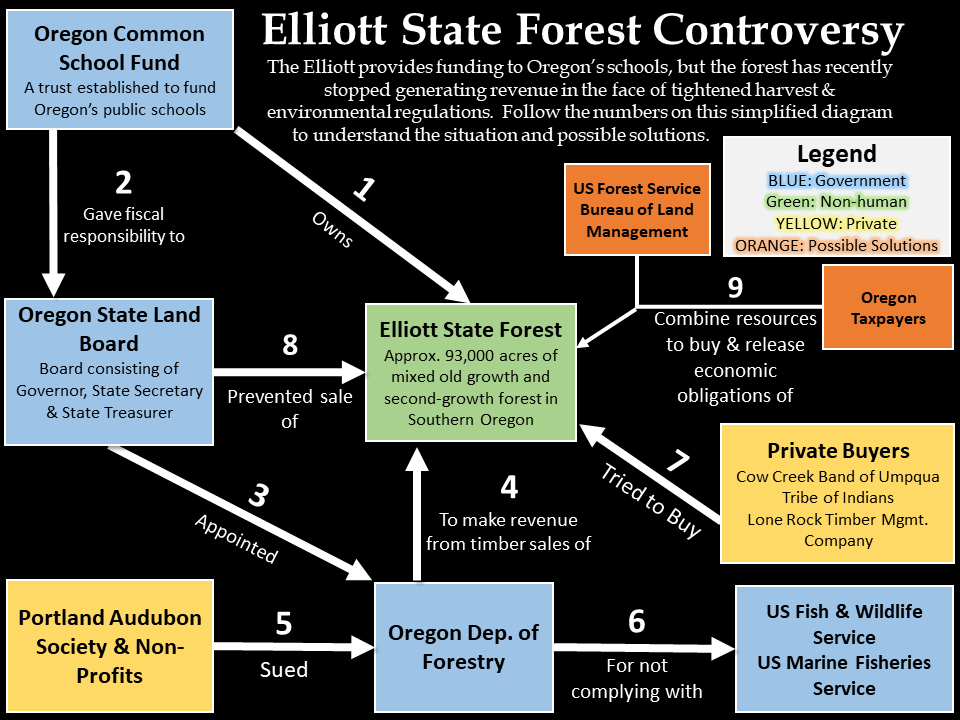
An easy-to-follow conceptualization of the recent Elliott State Forest controversy. Click the image to expand.
The Pacific Northwest is a colloquial term for the region of the United States that encompasses all of Oregon, Washington, and parts of Idaho and Montana. Thanks to its relatively intact landscape, this region contains habitat for many flagship species of interest – spotted owls, marbled murrelets, and salmon, to name a few. Much of this region is publicly owned, either by the state or federal governments, under varying degrees of management ranging from the preservation-minded National Park Service, to the multiple-use mindset of the Forest Service, and everything in between.
One of these publicly-owned tracts of land is the Elliott State Forest, established in 1930 from land previously managed by the adjacent Siuslaw Nationa Forest and currently covering 93,003 acres (288 sq. miles) of contiguous forest. The area contains patches of forest at different levels of succession, from virgin old-growth to mature second-growth and recently logged. This link will take you to the forest’s fragmented and heterogeneous successional land cover.While other nearby forests place large emphasis on recreational use, the Elliott State Forest’s primary function was and is to generate revenue for Oregon’s public schools through harvesting and selling timber. According to the 2011 Elliott State Forest Management Plan (EMP), the Elliott has contributed over $900 million to the Common School Fund, which directly and indirectly funds Oregon’s public school education system.
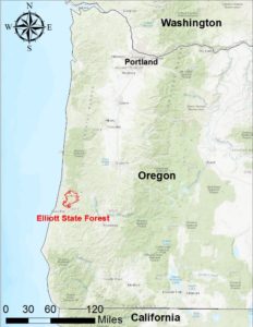
The Elliott State Forest (in red) in context within the Pacific Northwest region of the U.S
Starting in 2013 though, the forest’s profits have plummeted to the point that the forest profits do not account for the costs of its ownership – Oregon is no longer making any profit from harvesting and selling timber on the Elliott. While academic literature is still skim on this topic due to its recency, many news outlets report that a slew of environmental regulations have been restricting or altered logging practices in the forest, and this change is causing the forest to lose money. In the face of continuing financial losses, the state created the Elliott State Forest Management Plan of 2011 to balance “…sustainable timber harvests and revenue, diverse habitat for native species, properly functioning stream systems, and recreational opportunities.” Despite this new plan, a trio of non-profit organizations sued the state government for violating the Endangered Species Act by logging known habitat for the marbled murrelet (Audubon Society of Portland, 2014). The state cancelled timber sales as a result, and overall timber harvest dropped from 40 million board ft/yr to 15 million board ft/yr.
In June 2016, the state announced its plans to sell the Elliott, with the most current bidders being the Lone Rock Timber Company and the Cow Creek Band of Umpqua Tribe of Native Americans. However in May 2017, a last-minute effort spearheaded by Oregon governor Kate Brown and the state treasurer generated enough momentum to keep the forest public; the current plan is to temporarily relay $100 million to Oregon taxpayers to cover for the lost money and costs of the Elliott.
The future of the Elliott is still unclear, as those for and against selling the land vie in the age-old battle of private and public lands management. Court appeals to overturn the governor’s May 2017 decision, and no doubt this issue will test many Oregonian’s stance on public and private lands. The ultimate outcome of the Elliott will be an epitome example of the modern era of environmental issues and will likely affect the future political economy surrounding such issues.
So what are the viable options for the Elliott State Forest? Will Oregonians and the state government continue a relentless battle of public vs. private lands, or will a clear solution emerge from the many that have been proposed?
Another option that has been mentioned in a crucial 2014 alternative management report is the transfer of the Elliott to federal ownership either through a direct sale or exchange for equivalent federal lands (Ore. Dept. of State Lands, 2014). This option, which holds substantial potential, already has many real-world successful examples in the cases of Minnesota’s Boundary Waters Canoe Area Wilderness land exchange, Colorado’s Crag and Wilson Peak land exchange, and numerous others. Federal land trading and acquisition follows an established protocol that allows the federal land management agencies like the Forest Service (USFS), the National Park Service, or the Bureau of Land Management (BLM) to legally acquire ownership of lands.
In order to illustrate that a combination of the federal land exchange and a decoupling of timber harvest activities from the Common School Fund is the most viable option, I will employ the following methods:
- Spatial Analysis: With ArcGIS software and publicly available spatial data on the geography of federally-owned lands, I highlighted potential federal land parcels that could be exchanged for ESF. Potential candidates for land exchange included lands located in the Siuslaw, Umpqua, and Rogue River-Siskiyou National Forests as well as Bureau of Land Management lands. My analysis also involved identifying areas of federal forestland that would benefit most from state acquisition.
- Feasibility Analysis of Federal Land Exchange: I researched the logistics and feasibility of a federal land exchange by examining standard governmental procedures and several case studies including Minnesota’s Boundary Waters Canoe Area and Colorado’s Wilson Peak, both current land exchanges between private landowners and the USFS.
- Evaluating ESF land via previous cases of similar occurrences (Minnesota State & USFS)
- Evaluating ESF lands via previous studies as well as the Uniform Appraisal for Federal Land Acquisitions, the standard national manual for acquiring lands.
- Financial Analysis: Finally, I monetized the various social, economic, and environmental benefits of trading the ESF to federal agencies and compared this to the same array of outcomes for other management options, namely 1) the maintenance of the status quo (create HCP’s, continue harvesting, and maintain state ownership) and 2) an outright sale of the ESF to private buyers. These options are extensively examined by Sim et al., 2014.
Please click here to read the in-depth report in its finalized thesis form.
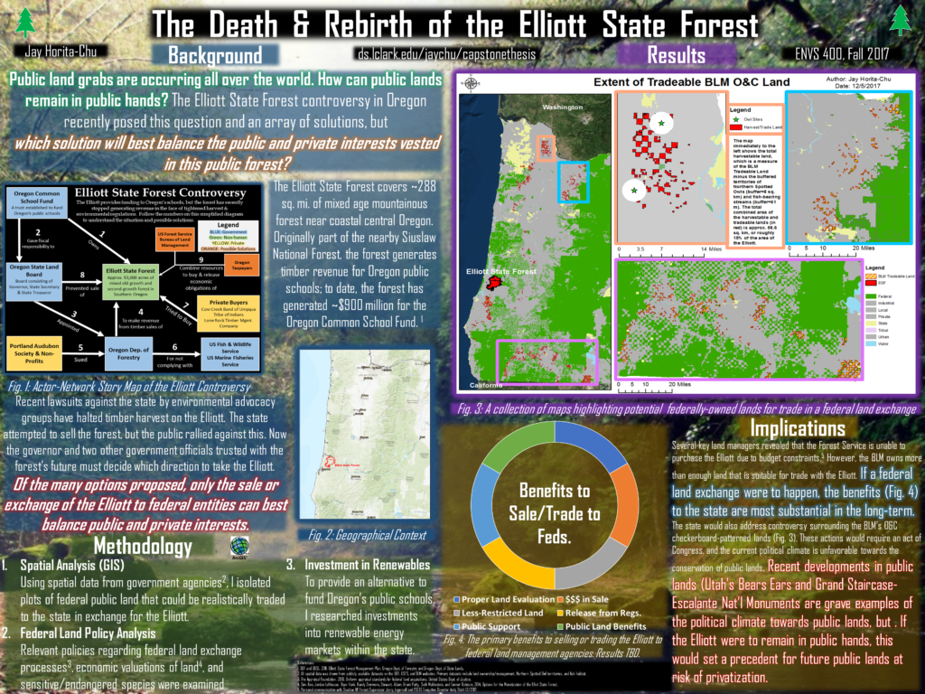
This high-resolution poster distills the main findings of my research down into a few short paragraphs. Please click to enlarge
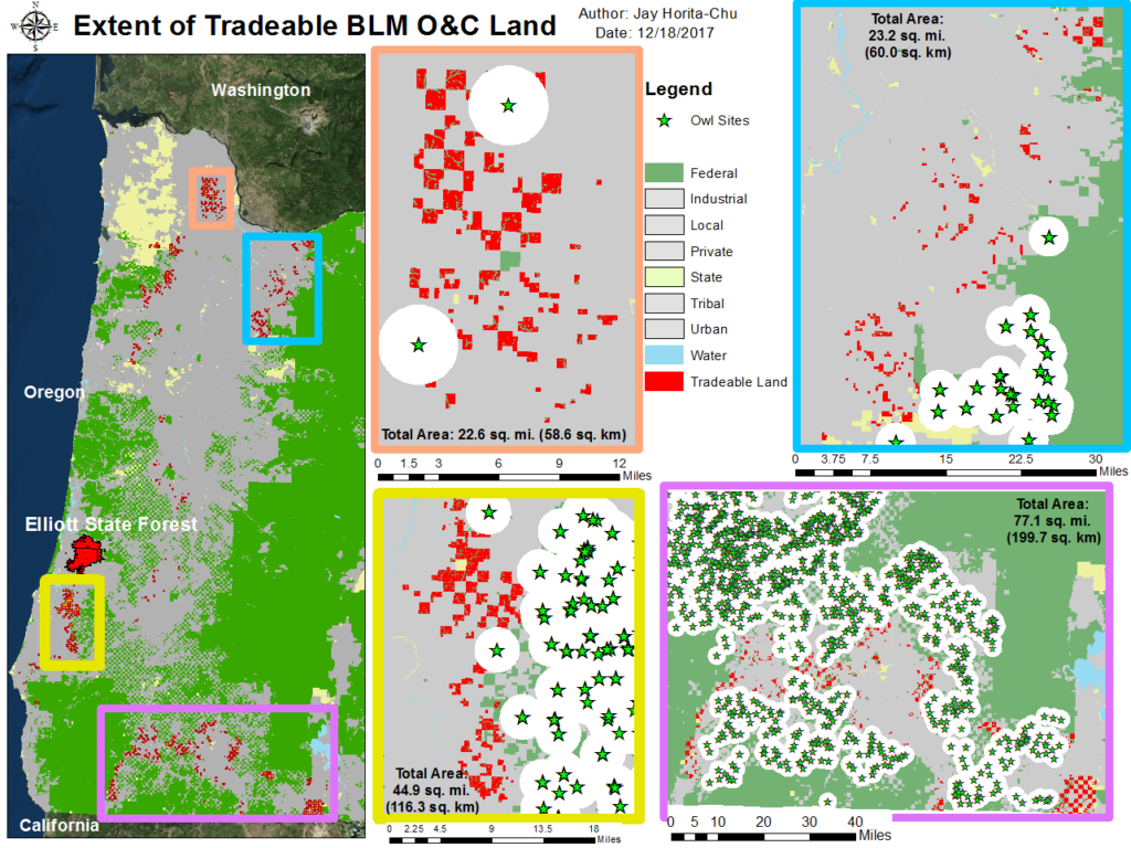
A three-part map showing various land ownership in Oregon. The Elliott State Forest is highlighted in red. Of note is the contiguous nature of certain federal lands vs. the fragmented BLM O&C lands.
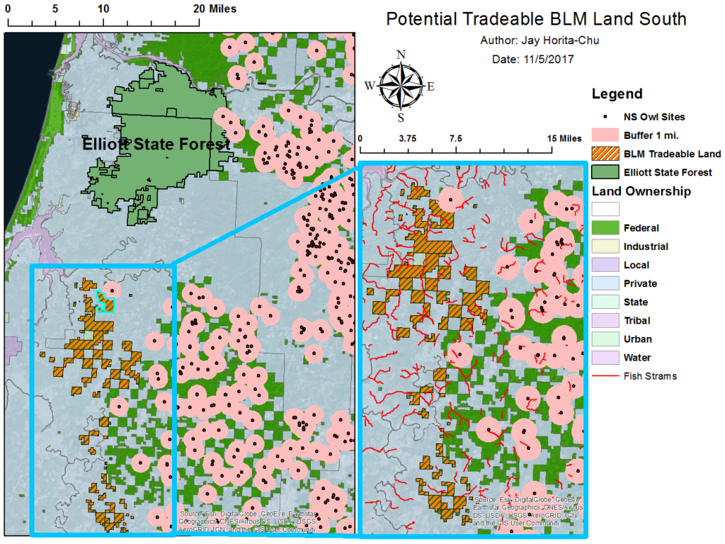
Using ArcGIS software, I isolated numerous O&C Land tracts that could be consolidated and traded to the state in exchange for the ESF. To prevent litigation from environmental groups, I specifically chose parcels of land that lay outside of key Northern Spotted Owl territories (Murphy and Noon, 1992); furthermore, I imported data on existing Spotted Owl nest sites and placed 2 mi. buffers (total of ~8 km2) around each site. According Murphy and Noon 1992 and many other 1990’s era studies, Spotted Owls consider more than just forest size in determining habitat suitability. However for the simplicity of spatial analysis, I assumed that owls require a minimum of 4 km2 of contiguous habitat; to err on the side of caution, the buffers I used were approximately two times these minimum required territories of these owls. Secondly, I placed 200 ft. buffers around each stream that harbored sensitive fish species OR streams that were labeled as High Aquatic Potential (HAP); the current regulation is to place a buffer twice the length of the trees surrounding fish-bearing streams (Ore. Dept. Forestry, 2012). For most of the parcels I chose, 200 ft. is more than twice the length of the trees found on the land. With both owl and fish habitat buffers accounted for, I summed the areas of the chosen O&C lands to be 167.8 mi2 (432.5 km2). In comparison, the total area of the Elliott State Forest is 376 km2. Although it is important to note here that a federal exchange of land is not based on the areas of land parcels in question, it is regardless important to note that there is more than enough O&C land that could be traded for the ESF. The map above shows the results from this portion of my analysis.
Through the O&C lands analysis, I outlined 167.8 mi2 (432.5 km2) of land that could be realistically traded for the ESF. Timber harvesting on these lands would generate comparable revenue to logging on the ESF with additional benefits such as: 1) absence of endangered and sensitive species 2) no obligation to create HCP’s and 3) less rugged terrain, which lowers operating costs and prevents potentially destructive landslides and 4) solving long-standing controversy surrounding the O&C lands. Maintaining public ownership of the Elliott also manifests long-term social and environmental benefits, namely 1) public access and recreational offerings 2) economic benefits to nearby communities stemming from the ESF's recreational offerings 3) ecosystem services such as carbon sequestration 4) an accurate land valuation of the ESF and 5) public support and preventing costly litigation from environmental groups. Conversely, the primary drawbacks of this option would be the absence of immediate, short-term economic benefits to the state and a lengthy land exchange process.
Perhaps equally as important as the outcome of this controversy is its place in current issues and political climate surrounding public lands. The Elliott joins the ranks of countless examples to privatize public lands, for better or for worse. Within the same month as the writing of this research, the largest “land grab” in U.S. history occurred when President Trump declared an 85% areal reduction to the Bears Ears and Grand Staircase National Monuments – a combined total of approximately 2 million acres. It is at once both apparent and alarming that the Elliott is not nearly alone in its dilemma.
Sentiments in the U.S. toward public land have fluctuated over the many decades since the realization of public lands. A decade of pro-public land and environmental policies contrast sharply against subsequent periods of hostile sentiment against new public land acquisitions and de-regulation. The 8-year period of the Obama administration was overall a pro-public land era; it saw the creation of approx. 550 million acres of new public land. However, the Trump administration provides a sharp contrast, even without the recent de-sizing of the two national monuments mentioned previously. The Elliott controversy unfolds during this greater political shift. This is Oregon’s opportunity to counteract or conform with this national trend. Indeed, what is decided about the future of this forest will no doubt portend the fate of other Oregon’s state public lands that will, one day, face the same trials and tribulations.
The solution to the Elliott State Forest Controversy is hindered by competing interests from the private and public sectors; however, the many thousands of human hours that have been invested in this controversy reveal a consistent theme – a sentiment shared by Oregonians west and east of the cascades. Perhaps no one has stated this sentiment better in formal terms than Roger G. Lord, the state certified property appraiser who authored the crucial land appraisal report of the Elliott:
In 2014, the Department of State Lands undertook an extensive evaluation and public process around future options for the Elliott... Two consistent themes were heard from a wide range of stakeholders: 1) the model of relying on forest land management to generate school funding is outdated, and it is time to decouple or separate decision-making about how best to manage public lands from decisions about how best to generate revenue for schools; and 2) there are many public values associated with the ESF, and most believe these values need to be protected regardless of what the Land Board decides about the future ownership and/or management of the Elliott. (MB&G, 2016) (p. 5-6, Emphasis not original)
In the current deeply divided political climate of the left and right, few examples of bi-partisanship exist. Public lands across the U.S. are victim to this liberal-conservative left-right divide and its consequences; the future options of the ESF however hold benefits that would appease parties regardless of their political beliefs. Transferring ownership of the ESF to the USFS or BLM would keep the Elliott in public hands, a move that would certainly please environmental groups and pro-public land members of the public. A trade for a portion of the O&C lands would allow the CSF to retain land for timber harvesting – something that would benefit local timber companies. The de-coupling of O&C land from federal hands would be a step in the right direction for the controversy surrounding the O&C lands as well. Ultimately, this trade supports both private and public interests and balances the diverse array of social, economic, and environmental benefits that stem from this forest. Perhaps what Oregonians must do then to counteract national anti-public land politics, balance competing interests, and save the Elliott, is rebirth these great forests and hills of the Coastal Oregon range as the Elliott National Monument.
Posts
Steps Forward in Spatial Analysis & Poster Design
As the end of the semester looms ever closer, deadlines are fast approaching. In preparation for our preliminary poster sessions next week, I have completed a draft of my poster. It’s been a huge push to get everything onto the 30″x40″ poster, but I’m happy with how it’s turned out! In the near future, I […]
The Outline of the Century
Outlines are a simple tool to break down the main ideas of a long paper. As one of my outcomes will indeed be a lengthy thesis paper, I’ve written up a very rough outline that will guide the progression of my writing. I predict that much of this will change as I complete my […]
New Progress & Reflections on Past Topics
Much of our time in school is spent studying past material, but in my thesis research, I have to combine both current and historical material to be successful in creating relevant and applicable results. As such, I’ve done a few things this past week, including popular news media analysis, a reflection on my recent “madlibs” […]
With the few weeks left…
The end of the semester is on the horizon. To help my productivity stay high, I have created a timeline for the remainder of this semester. Obviously, there are many many things to do still, but laying them out in chronological order will present this mountain of work in more manageable bite-sized pieces. 11/12 Literature: […]
Good Step Forward with Spatial Analysis
While I started pulling some spatial data off the internet some weeks ago, this week I managed to do some initial spatial analysis with the data! It’s exciting to brush off my old ArcGIS skills and gain new ones as I move forward with step one of my methodology. While in no way complete and […]
Easy Access Academia
Good scholarship not only maintains a high rigor of academic expertise but also a relate-ability to lay audiences, and in this spirit, I have created a simple method to understand the broad situation of the Elliott State Forest controversy. While not a perfect representation of the many subtleties of this situation, this diagram will allow […]
One Road to Rome pt. 1
Today marks the point in my thesis research when I begin constructing, de-constructing, and analyzing the immense mountain of spatial data I’ve collected in the past month and a half. The question remains the same: What is the best option the state of Oregon has to maintain the Elliott State Forest’s economic obligations to the […]


