Over this past week, I attended the most recent public meeting on the Residential Infill Project. This was the presentation of the City of Portland’s changes regarding RIP to the Stakeholder Advisory Committee, following the public feedback gathered over the summer. There were relatively few changes made to the Residential Infill Project as a result of the most recent public feedback process. One modest alteration was to move from the categorical/kinked house size limits by lot size to standardized FARs (Floor Area Ratio), with 3 different FARs for the R2.5, R5, and R7 zones. This was an attempt to rationalize the implementation of the code and respond somewhat to the zoning context, permitting smaller total floor area in lower intensity zones. Secondly, they added a recommendation that calls for providing “added flexibility for retaining existing homes,” an attempt to address concerns about demolition by making reuse of structures more attractive. The recommendations involve allowing for modest additional floor area and height for remodels and additions and allowing an additional unit inside the Housing Opportunity Overlay Zone when an older house is converted into multiple units. And finally, they adjusted the boundary of where the proposed denser housing types can be added. This is now called the Housing Opportunity Overlay Zone (HOOZ) and has been adjusted to include, in addition to areas within 1/4 mi of centers and corridors, those areas designated as medium or high opportunity zones or as Inner Ring neighborhoods by the City of Portland. The main neighborhoods added by this change are Irvington and Eastmoreland—two areas whose neighborhood associations have been quite opposed to the added density proposed by RIP. We’ll see how those changes are taken at the City Council public hearing. Additionally, the HOOZ is proposed to indefinitely exclude areas within the David Douglas school district in East Portland, until they address school overcapacity issues.


Beyond learning this information about the modest changes to the proposal, it was interesting to see the social dynamics of the meeting. Rick Merrick was the most vocal of the neighborhood preservation bloc, criticizing the project as “rezoning the entire eastside.” Morgan Tracy, the urban planner from BPS, responded by admitting that in many ways it is, but characterizing the changes as a move towards a form-focused code. Merrick was vocally unsatisfied with this response, saying that it was destroying the entire basis of single-family zoning. Someone from the Planning and Sustainability Commission stepped in to point out the existing exemptions within the single-family zoning code (ADUs, corner duplexes).
Additionally, I conducted my social network analysis, moving all of the data I listed out into nodes and edges tables. Each unique actor was a node. Each relationship between the organizations (largely the affiliation of members of commissions, though also including bureaucratic organization, organizational members of coalitions, and organizations endorsing 26-179 or UNR’s demolition letter) is an edge. After importing the data into Gephi, I filtered out those nodes with only 1 connecting edge, scaled the node size to the “betweenness centrality” (measures how often node appears on the shortest path between nodes), set the color of nodes to the “Eigenvector Centrality” (measures importance of node based on the node’s connections), and ran the Force Atlas 2 algorithm, adjusting the parameters to obtain a relatively ordered graph.
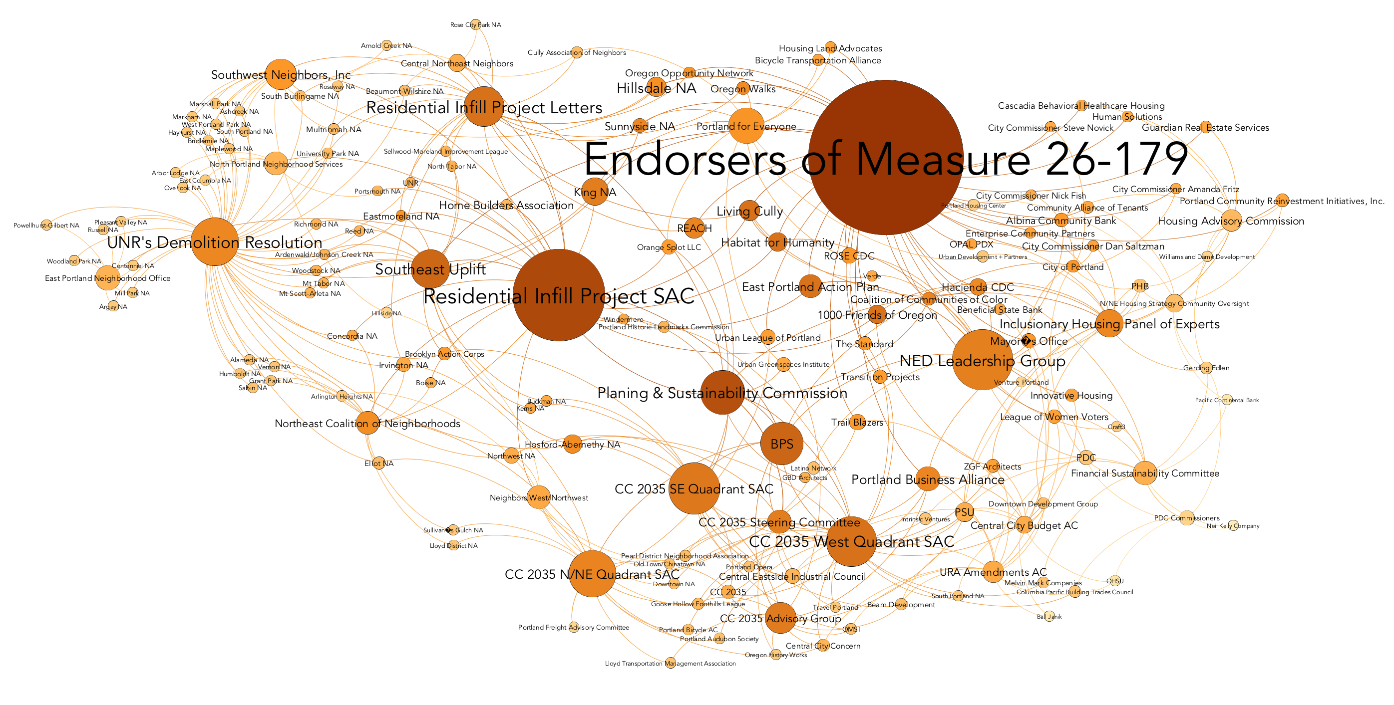
The RIP SAC plays a relatively important role within this network, as measured by betweenness centrality and Eigenvector centrality, despite its relatively low degree. This is seemingly due to the RIP SAC’s connections to district coalitions, development agencies, and nonprofits, bringing together the two sides of the network. After making this graph, I realized that I had neglected to add the Office of Neighborhood Involvement, which would likely connect the left and right areas of this graph more, as it would provide a direct edge between the City of Portland and the various district coalitions. Additionally, I may add nodes and edges pertaining to the constituent organizations represented by actors like the Portland Business Alliance or Central Eastside Industrial Council. I will also categorize each node by the type of organization/actor, to provide a better overall schematic illustration of trends in the network. Finally, I will explore options for obtaining and interpreting network statistics for the nodes and edges.
Finally, I researched more about the history of Portland’s public engagement process and neighborhood associations, relying largely on The Portland Edge: Challenges and Successes in Growing Communities and Better Together: Restoring the American Community. The Portland Edge contained several chapters directly pertaining to public engagement in the planning process. One chapter covered the PDC’s historically opaque operating mode and its limited attempts at reform in the 00s. Gibson characterizes the Urban Renewal Advisory Commissions created to deal with the Interstate and Lents Renewal Areas as token public engagement, being numerically dominated by business interests and consistently shaped by PDC officials, who controlled the flow of information within the group and leveraged their technical knowledge to obtain the institutionally-desired results. I saw many parallels between this description and the operation of the Residential Infill Project SAC.
Two other chapters in The Portland Edge and one chapter of Better Together directly treat the issue of the history of Portland neighborhood associations. Both spin narratives of Portland being an ordinary American city in the mid-20th century, with public engagement being limited to consulting business elites in smokey downtown rooms. They note the broad-based, national phenomenon of increased civic engagement and activism in the 60s, which developed alongside new models of public engagement like the Model Cities initiatives. In Portland, Neil Goldschmidt institutionalized these incipient forms of organization in 1971 with the creation of the Office of Neighborhood Associations, thereby beginning a process of expanded neighborhood involvement in the 70s and 80s, with many neighborhoods playing a large role in the creation of neighborhood plans. Views on the trajectory of the neighborhood associations since the 80s are somewhat more divergent, with Witt (2004) seeing dialectic cycles in the positivity or hostility of the city to neighborhood association relation, Johnson (2004) seeing a secular decline in neighborhood power, and Putnam et al. (2003) seeing the continued excellence of Portland’s neighborhood planning process relative to other cities, albeit with some examples of failures.
Leave a Reply