First, the spatial relationship I found between the socioeconomic measures of gentrification and land value appreciation supports my decision to use land value as a fundamental indicator/driver of gentrification processes. Land value, unlike home value, racial change, shifts in median income, or change in college education, blends gentrification typology; land appreciation cuts across downtown/neighborhood distinctions and reveals the core-centric nature of gentrification in Portland. This landscape of gentrification is closely aligned with the landscape of frequent transit provision, in terms of both historical development patterns and the present day network.
Secondly, my results indicate that transit plays an independent role in shaping appreciation, beyond the degree to which is simply correlated with core proximity and the overlap between the historic urban form and present transit provision. there is a statistically significant relationship between rail and land value, land appreciation and all frequent transit. Overall, the coefficients from this regression indicate that, holding all else equal, a 5,000 square foot lot (typical for Portland single-family residential zones) a tenth of a mile from rail transit will be worth $16,500 more than one 1/4th of a mile, $28,500 more than one half a mile away, $41,000 more than one a mile away, and $53,500 more than one two miles away. This same 5,000 square foot lot would have also appreciated by $10,900, $19,000, $27,200, and $35,600 more than ones 1/4 of a mile, 1/2 a mile, 1 mile and 2 miles away from rail. A similarly generic lot within a tenth of a mile of frequent buses would have appreciated by $3,250, $5,500, and $8,000 over lots 1/4 of a mile, 1/2 a mile, and 1 mile from transit.
This regression was able to account for 61% of the variance in current land values by block, with less accounted for during the shorter periods and especially in the 2009-2012 (recessionary) period. To a large extent, this decreased variance explained with decreased time analyzed reflects a fundamental error in the data source used; assessed land values seem to be updated in chunks, with highly defined bounds in terms of short-term appreciation. The fact that the NW-PSU streetcar and Yellow line present a robustly positive relationship with land value for the whole period since their opening and an insignificant one for the immediate three years after opening, indicates, however, that something somewhat more significant may be hiding in the noise. Knapp et al (2001) found that land value alongside Portland’s Westside MAX line rose dramatically in the first year after the light rail plans were announced. There then may be a lag between this speculative increase and a capital-driven increase in land value over time, whereby investments in a neighborhood make the land itself more valuable.
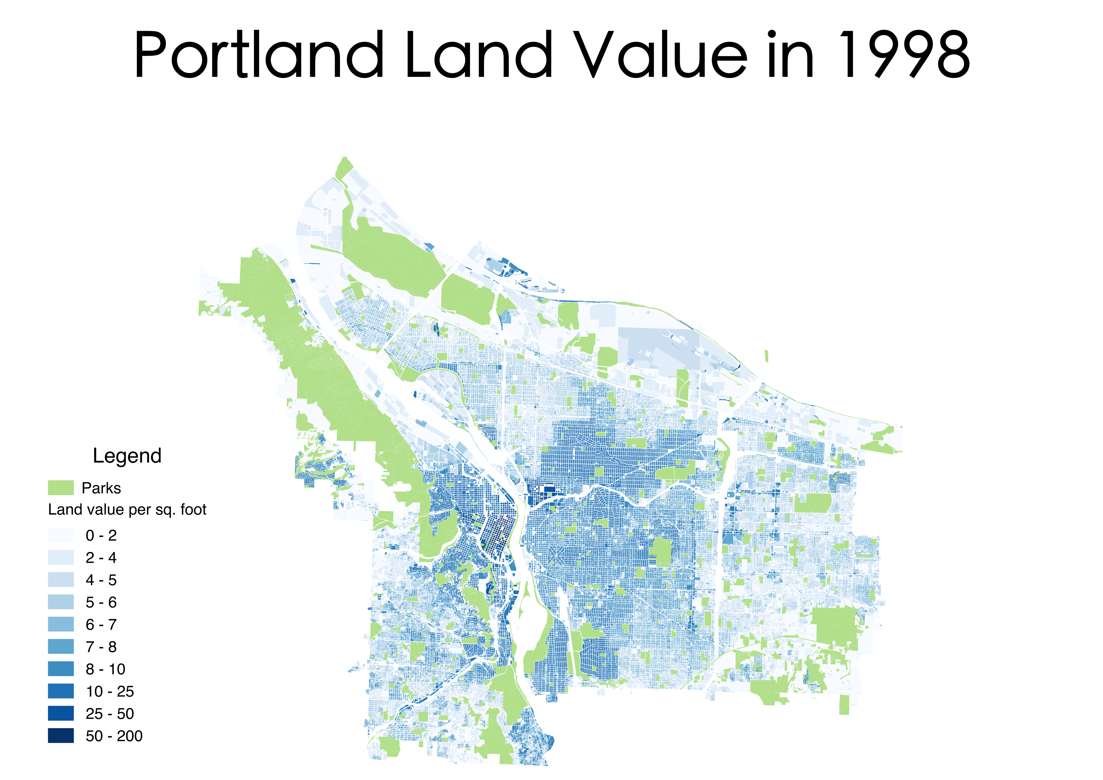
Rent gap visible in North Portland 1998 land value
These relationships, however, must be accompanied by the caveat that appreciation and gentrification along the Yellow Line in North Portland is in many ways overdetermined. There was a massive rent gap visible in 1998, with undervalued land in the area conterminous with the historic black population. Gentrification of such an area would have likely occurred without transit, and was indeed underway before the construction of light rail. Moreover, the most signifiant spatial and demographic transformation of North Portland occurred more than half a mile away from the direct path of the Yellow Line, in the core of the Albina district around Mississippi Ave and N Williams. Finally, there’s been relative (and sometimes absolute) depreciation in East Portland, regardless of transit access. Though the city intends to focus growth/revitalization there, especially along the Blue and Green lines, few effects of the designated Gateway and Lents urban renewal zones are observable thus far.