The purpose of georeferencing is to turn nonspatial imagery, such as historical air photos or maps, into spatial raster data for use in a variety of circumstances. Spatialized air photos, for example, can be used for GIS land cover analysis or to use as a baselayer on a mobile device while in the field. Below you will find instructions for georeferencing on three different platforms: Google Earth, ArcGIS, and QGIS.
Click image to expand
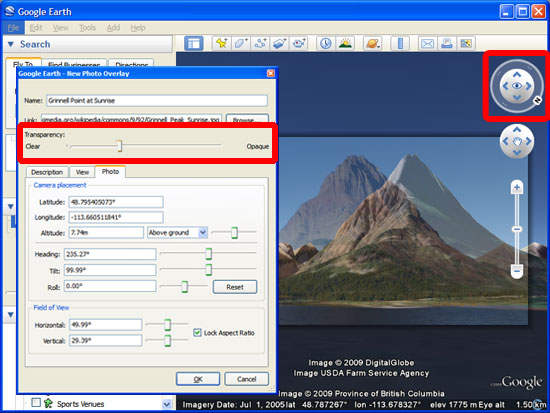
How to georeference in Google Earth
Although ArcGIS and QGIS provide the tools to perform the most accurate georeferencing, Google Earth supplies the image overlay and photo overlay features which not only allow you to georeference aerial imagery and maps, but also overlay photographs of buildings, mountains, or other terrain to be viewed in a 3D manner, as seen in the image to the right. These georeferenced images could easily be incorporated into a Google Earth tour. In order to add a new image or map overlay select the image overlay button or to add a photo overlay go to the Add menu, and choose Photo. There are tutorials and help pages which can help you through these processes.
How to georeference in QGIS
For more accurate georeferencing you will likely want to use ArcGIS or QGIS. If you have a map where you already know the coordinates (for example, if you were out in the field taking GPS coordinates of specific locations or if the map contains a coordinate grid with markings) this georeferencing tutorial will be sufficient. If this coordinate information is not available to you, the QGIS user manual provides you with instructions for how to attach a spatial reference to your image by using a satellite baselayer.
Tips: Remember to have a baselayer loaded onto your blank map on QGIS before beginning. Google Satellite layer is usually a good option (Plugins > OpenLayers plugin > Add Google Satellite layer). When you are prompted to enter a transformation type when you are done choosing your control points, the higher-number polynomial transformations are probably what you are looking for if you chose at least six control points. For resampling method, nearest neighbor is usually a good choice. Choose Load in QGIS when done so that you can check to see if the image has georeferenced properly.
How to georeference in ArcGIS
Georeferencing in ArcGIS is a similar process to the QGIS documentation found above, but you will want to follow this ArcGIS help page or this georeferencing tutorial for all the specifics. Remember that it is important to identify a sufficient number of accurate locations common to your nonspatial image and reference layer. Three reference points is the minimum, but try and identify more. After you are done georeferencing, always compare your newly georeferenced image with a baselayer for accuracy.