Click to enlarge image of research sites
Researchers: Gabe Kohler, Keith Morency, Peter Nocka, Julie Oatfield
One of the major goals of our overseas study program was to better understand relationships between people and the biophysical environment around Mt. Fuji. In addition to studying interpretations of the “natural” world in artwork, literature, consumer products, and so forth, we observed direct interactions between people and their biophysical environments, and looked in particular at human impacts on forests and grasslands. In order to provide a consistent frame of reference, our analysis centered on the various ways that traditional common lands use rights (iriaiken) are exercised at each sample site across the Aokigahara, Kenmarubi, and Takamarubi lava flows. With the help of Dr. Andrew Bernstein, Associate Professor of History at Lewis & Clark College, and Watanabe Michihito, Director of the Fuji Nature Conservation Center, we were able to study in places with notable changes in land use over the 20th century and to conduct research on how people have used the diverse areas of the mountain’s base over time.
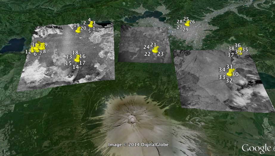
Below is a link to a KMZ file which documents our data collection over four days of historical fieldwork. The file will open in Google Earth and contains geolocated pictures documenting important findings. We used the Fulcrum Survey application to take and annotate geolocated photos while in the field, which were then exported as a KMZ file. At the end of this post is a key that explains each picture. We recommend downloading the KMZ file, as we will reference specific photos throughout this document. Within the KMZ are three historical aerial photographs overlaying each of the three lava flows that we investigated. These can be removed by unchecking the overlay files on the left side of the Google Earth window. The overlay of the Aokigahara lava flow (farthest west) is an aerial photo from 1970, the overlay of Kenmarubi (central) is from 1970, and the overlay of Takamarubi (farthest east) is from 1957.
Final Report KMZ (20 mb)
Our historical survey and investigation of the Aokigahara, Kenmarubi, and Takamarubi lava flows in Yamanashi Prefecture was designed alongside two other accompanying investigations, botanical and geological. In consideration of these two other groups, we decided to focus solely on the history of human activities on and nearby these three lava flows. In collaboration with the other groups, we settled upon the general goal of investigating how the three lava flows differ in respect to botany, geology, and human activity, and how these elements have changed over time. By keeping the research “question” relatively open-ended, we were able to leave each group plenty of freedom in designing its specific survey, while at the same time making it possible to relate our findings effectively. We decided to pursue questions concerning what evidence of human impact exists at sites on and adjacent to each of these lava flows, and how activities within these sites changed due to major events (such as natural disasters, wars, or economic booms and busts) and an ever-evolving natural landscape. As we explored each of the sites both in person and in historical aerial photos, we noticed general signs of land use that included coppiced trees for firewood, stumps from logging, and infrastructure between villages and resource sites such as roads and transport equipment. Aerial photos featured on the Geospatial Information Authority of Japan (GSI) website, which cover most decades of the 20th century and most of Japan’s physical geography, provided visual clues for points of interest (http://mapps.gsi.go.jp/maplibSearch.do). By collecting data and comparing our results with Watanabe’s knowledge of the area, historical photographs, and scholarship on land use changes over time, we were able to come to a better understanding of the close relationship of people and diverse biophysical environments in the Mt. Fuji region.
With help from Bernstein, we decided on a process of reviewing maps and aerial photos, as well as consulting with Watanabe, to select two relevant places to investigate on and/or next to each lava flow. This way we would not only find interesting places to survey, but we would also have a little background information on what had been going on there through much of the 20th century, and perhaps know what to look for. Upon reaching a site we would break into smaller teams and search for appropriate clues to any human interaction with the landscape. The three most important clues that we recorded were stumps as a sign of logging, older roads or infrastructure, and coppiced trees. The geological and botanical groups agreed to follow us to these sites so that we could provide a historical context for their data, and in turn we could understand the environmental conditions surrounding human activity there.
After viewing two representative sites at each lava flow, we began to observe patterns of woodland use. Across the three lava flows, and at the two sites that we visited at each flow, we noticed three different types of human impact: coppicing, selective cutting, and large scale plantations (which could indicate clear cutting patterns). These impacts could be tied to different actors, some of whom are within the Japanese timber industry, others of whom are local residents. One actor that engages in all three land use patterns is the Onshirin Kumiai. When talking about land use in Japan, an important consideration is that property rights differ from use rights. The Onshirin Kumiai is a local association that exercises traditional common lands use rights, referred to as “iriaiken,” on the north side of Mt. Fuji where our research was based. While the land under its jurisdiction could technically be listed as prefectural land (Aoki_Sites 1,2,3; Taka_Site 1; Ken_Site 2), the prefectural and national governments still recognize the Onshirin Kumiai’s historical claims to the land and allow it to both harvest and plant according to need.
In addition to finding coppiced oaks close to timber areas, we also found some growing near the Takamarubi lava flow in the Nashigahara grasslands. We heard from Watanabe and a few other group members that oak tolerates fire, even thrives with it, as germination is accelerated by extreme heat. So, these trees stand up well to the annual burning of the grasslands which have been taking place in this area for hundreds of years. Village groups exercising their iriai land use rights traditionally used these areas as a source of grass for feeding horses, thatching roofs, and fertilizing fields. They also collected herbs and made charcoal from the kashiwa oak (Quercus dentata) that grows well because of the relatively fine-grained substrate (compared to atop lava flows) and regular burning. We walked around the Nashigahara area, which is still maintained as a grassland today (iriai practices are still exercised, though more as a symbolic reassertion of the iriai rights holders’ legal permission to use the land). Japan’s Self-Defense Forces (SDF) have also leased the land since the 1970s and benefit from the regular burning. Bernstein summarizes the relationship between the grasslands and the groups of people utilizing it, and how this relationship has shifted over the past century: “Today local groups and the military are in as symbiotic an embrace as ever, but now iriai practices are aimed not at drawing physical sustenance directly from the land, but at perpetuating a terrain for goals both military and economic” (Bernstein, 9). Specifically, the ecosystem of the grasslands is kept at an earlier successional state, which is better suited for target practice and other military training purposes. At the same time, individuals are still allowed to harvest grasses and herbs as needed, which we observed on the side of the road while looking for endangered butterflies with Watanabe.
When consulting Watanabe about the different timber extraction methods exercised by iriai communities and other users over the last several decades, he indicated that these methods are closely linked to different types of uses for the timber. Until the mid-20th century, iriai practices mostly involved acquiring resources for smaller-scale use in villages, such as selectively cutting trees for construction and coppicing oaks for daily firewood/charcoal. We witnessed coppicing of smaller types of oak such as konara and mizunara (both are quercus serrata, but look different) across all three lava flows which are clear indicators of timber extraction for personal use (Aoki_Site 2_Pin 12; Aoki_Site 3_Pin 14; Aoki_Site 3_Pin 13; Taka_Site 1_Pin 30; Taka_Site 2_Pins 36, 37).
At most of the sites where we observed coppicing activity, we also noticed some selective extraction of whole trees, usually Japanese red pine (Pinus densiflora) and cypress (Chamaecyparis obtusa), which could be used for local construction efforts. Large scale aerial photos of the area gave us clues as to the types of locations that would be most prone to this form of use. We looked for nearby villages, as this type of small-scale cultivation would have been limited to close proximity to roads and more physically accessible landscapes such as the grassland near Motosu (Aerial Overlay; Aoki_Site 2_Pins 6-12). Coppicing for firewood and charcoal was one of the earliest ways of exercising iriai rights. A larger suite of traditional forest uses (mushroom cultivation, harvesting of grasses, traditional artisan crafts, etc.) remain important to many communities today, despite the transition from wood-fired heating and cooking to the use of gas.
The presence of hinoki (cypress) stumps of various ages was observed at several different sites across the three lava flows (Aoki_Site 2_Pin 10; Aoki_Site 3_Pin 16; Aoki_ Site 4_Pin 19). We took this to be evidence of selective cutting, as these stumps were usually found in areas that were not plantation forests. They were also more likely to be surrounded by trees of varying species and ages, not characteristic of timber plantations. At these sites we noticed that in some cases the understory had been cut to allow for the extraction of the larger, more valuable timber (Aoki_Site 3_Pin 17; Ken_Site 1_Pin 23). Disasters such as the 1966 typhoon and landslide near Lake Saiko and a large fire near the Motosu grasslands in the 1970s led to a higher demand for cypress for reconstruction purposes. Iriai users then turned to nearby forests to harvest Japanese cypress in particular.
The events of World War II and the construction boom that took place in its aftermath created demand for large-scale timber harvesting, which encouraged iriai rights users to cultivate cypress and pine trees on plantations. Around this time there was a shift toward establishing plantation forests for large-scale logging as opposed to selective cutting practices for smaller-scale use of timber in nearby villages. Major roads through forests were developed to accommodate transport of timber, along with industrial-grade pulley systems and log “rafts” to get larger cypress logs onto these roads.
The transition of iriai land into plantation forests involved large-scale collective action and investment in infrastructure. Kara Batdorff’s thesis, “Mapping a Mountain: Mt. Fuji Land Cover Transitions Over the 20th Century,” illustrates the major land-cover transitions throughout the 20th century on and around Mt. Fuji. In order to encourage villages to plant trees to support the war effort, the Imperial government provided heavy subsidies and launched a massive campaign that included tree-planting festivals. At the same time, the government also began building roads near these new plantations to facilitate the quick removal of timber. However, many of these forests were cleared only once or never cleared at all due to a surplus of imported timber after the war, and were therefore left to grow largely unchecked. When examining aerial photographs taken in the 1940’s and 1950’s, we looked for infrastructure development near the edge of forests in order to locate sites that could potentially be these war- and postwar-era tree plantations. We located several sites that matched the description of these forests (Aoki_Site 2_Pin 11; Ken_Site 1_Pin 22).
Recently, the Onshirin Kumiai has been working to revitalize the timber industry in a more modern context by exploiting underused timber sources for bio-pellets. These bio-pellets are being advertised as an alternative, non-fossil fuel-based energy source for heating homes and other small spaces. Also, we noticed some forested areas being developed for recreation purposes. This is accomplished by allowing red pine forests to grow taller than normal above a cleared understory. A dramatic aesthetic that is not hampered by shrubbery on the ground is created, and visitors are welcome to walk along paths beneath the towering trees. This focus on new energy sources and recreation represents a new direction in the complex history of iriai land use and Japanese forestry.
It is sometimes difficult to distinguish which present-day forests were logged for cypress. A lack of cypress may indicate it was all cut in times of need and no trees were left to regenerate. On the other hand, plenty of cypress may indicate the trees were purposefully planted for anticipated use after older cypress trees had been logged.
Our first site was located near Lake Saiko on the Aokigahara lava flow. We picked the site because we noticed, while looking at a few decades’ worth of aerial photographs of the area, that a small town appeared on the edge of the lava flow in the 1960s. We also noticed a road that had existed throughout the 20th century running directly past the village. Assuming we might find some human activity in that area, we drove there and were promptly informed by Watanabe that a typhoon had wiped out a village around 1966, which was replaced by the village we had seen in the aerial photographs. Our survey of a site off the road near the town yielded some very interesting findings. We immediately noticed coppicing, which is evidence of fuel wood harvesting, and larger stumps as evidence of timber harvesting. In addition, we found an old timber transportation trail and the remains of a pulley system, used to transport timber out of the forest (see Aoki_Site 1). The findings at this site undoubtedly shaped the way we searched for sites in the subsequent days of fieldwork. Our observations on that first day taught us that human development has occurred in rather unexpected, apparently “wilder” areas like a dense forest atop an uneven lava flow at Aokigahara. We’ve learned how to keep an eye out for signs of human interaction with the ecosystem everywhere we go, and how these interactions have changed according to physical evidence and a broader historical context of land use in Japan.
REFERENCES
Batdorff, Kara. “Mapping a Mountain: Mt. Fuji Land Cover Transitions Over the 20th Century.” Senior thesis, Lewis & Clark College, 2014.
Bernstein, Andrew. “Guns and Grass: The Militarization of Fuji’s Common Lands.” Presentation Delivered at IASC annual meeting, June 2013.
Geospatial Information Authority of Japan (GSI), Ministry of Land, Infrastructure, Transport and Tourism.
mapps.gsi.go.jp/maplibSearch.do. Accessed July 24-28, 2014, with time frames on left-hand side adjusted to decades between 1900 and 2014.
Interviews and fieldwork with Michihito Watanabe, Director of the Mt. Fuji Conservation Center in Kawaguchikomachi, Japan, July 18-28, 2014.
Visit to Onshirin Kumiai headquarters in Yamanashi prefecture and interviews with its representatives, July 30, 2014. http://www.onshirin.jp/en/ (English website for the iriai association).
Aokigahara Site 1
1 – Road used for timber transportation near Lake Saiko
2 – Remnants of pulley system used for timber transportation
3 – Large cypress left uncut
4 – Remnants of culvert along logging road
5 – Evidence of cut logs and trash
Aokigahara Site 2
6 – Fire break/300-year-old road between Yamanashi and Shizuoka prefectures
7 – Grass mowed to maintain common land rights
8 – Access road running near the edge of the lava flow
9 – Evidence of logging: two stumps in the foreground, one in the back
10 – Large cypress stump
11 – Plantation cypress near lava flow
12 – Heavily coppiced oak stump near lava flow
Aokigahara Site 3
13 – Remnants of charcoal furnace, near heavily coppiced oak (mizunara) near Aokigahara lava flow
14 – Extensive coppicing on older lava flow, next to Aokigahara
15 – Large cypress stump on Aokigahara lava flow
16 – Group of small stumps: evidence of thinning to increase ease of logging cypress trees
17 – Log left after cutting, not for timber but for forest thinning to allow easy transportation of choice timber
18 – Bundle of cut logs near bigger stumps, used to carry out larger timber
Aokigahara Site 4 (Vicinity of Wind Cave)
19 – Stumps, possibly indicating logging
20 – Sign states area is “old growth natural forest,” which is not true judging by size and age of trees.
Kenmarubi Site 1
21 – Rotted red pine stump
22 – Old trolley road from postwar period
23 – Moss-covered logs felled during forest thinning
24 – Power station and power lines that run along the old trolley route
Kenmarubi Site 2
25 – Shrine with small wooded area and stack of wood
26 – Shrine with small playground and grassy area
27 – Shrine on lava flow
28 – Pile of cuts logs behind shrine
29 – Small shrine near railroad
Takamarubi Site 1 (Near Nashigahara)
30 – Coppicing near Takamarubi lava flow
31 – Planted enju (pagoda trees)
32 – Large cut trees
33 – Secondary trunks removed to make way for extraction of timber (observed at many sites on lava flow)
34 – Plantation in which trees are planted every year by elementary school students
Takamarubi Site 2
35 – Natural Monument Sign, forbidding tampering with area
36 – Stumps and evidence of cutting and coppicing in the area
37 – Relatively large, thick coppiced trees, probably not cut for thirty to forty years
38 – Tagged, numbered harimomi (tiger-tail spruce) tree. All harimomi trees are tagged for study.
39 – Very old stump near harimomi