Field research background
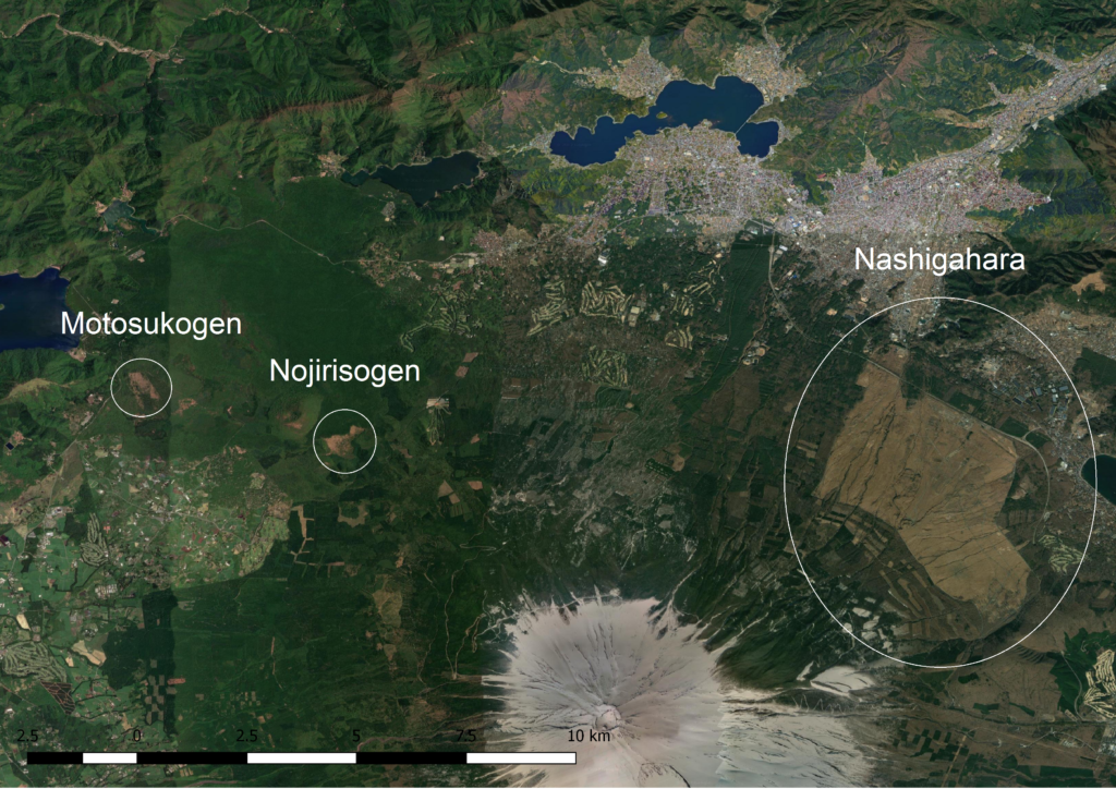
The Japanese concept of “satoyama” refers to the inter-related human and non-human processes occurring in managed rural landscapes consisting of woodlots, grasslands, rice paddies, and other kinds of agricultural fields in close proximity. Certain organisms thrive in these landscapes and contribute to Japan’s notable biodiversity, but migration from rural to urban settings combined with Japan’s declining human population has led, in many places, to reduced management of the satoyama. A number of plants and butterflies that thrive in grasslands disturbed by humans, for example, are now endangered. Through a combination of field reconnaissance and systematic data collection, students on Lewis & Clark College’s Mt. Fuji Summer Overseas Program spent about a week studying three grasslands on the north side of Mt. Fuji: Motosukōgen, Nojirisōgen, and Nashigahara.
Ecologist Watanabe Michihito of the Mount Fuji Nature Conservation Center served as our regional guide and also spearheaded one of three field investigation groups. Each group contained 4 students and focused on one particular topic at all sites visited: soils, plant communities, and butterfly populations. Watanabe headed the butterfly group, trip co-leader Andrew Bernstein led the plant group, and the other trip leader, Liz Safran, led the soils group. Students in each group worked together to formulate their own research questions, hypotheses, and data collection plans, which were then modified to accommodate the needs and questions of the other groups. Field data were collected with the Fulcrum survey application on iPad minis. At night, the mobile devices were synchronized, and any necessary changes to the surveys were made. Students kept data diaries, reflecting on the day’s field work, and cleaned up data from their field surveys. Ultimately, data were exported from Fulcrum into a variety of formats, including ESRI shape files or delimited text files, for manipulation or display in other programs, such as Excel or QGIS.
Student groups investigated the geologic and land-use histories of each of the grasslands; these are described briefly below. Links to the the soils, plants, and butterfly research groups’ final reports are at the bottom of this page.
Geologic and land-use characteristics of grassland sites
Motosukōgen
The Motosukōgen grassland is located on Fujinomya stage lava flows and pyroclastic debris erupted by Mt. Fuji from 15,000 to 6,000 BCE. According to Lewis & Clark alumna Kara Batdorff’s land use analysis (ENVS senior thesis, 2015), in 1898 the Motosukōgen was a “wasteland,” which is how grasslands (and other lands from which taxable income could not be derived) were then described. By 1930, planted broadleaf and coniferous forests had expanded into much of the grassland. The earliest aerial photographs available for the Motosukōgen grassland are US Air Force photos from 1947. These photographs show the Motosukōgen as a large grassy area surrounded by what appears to be plantation forest. No aerial photos dating from 1957 until 1970 are available. By 1970 we notice distinct borders formed by constructed firebreaks separating the grassland from plantation forests. At some point between 1975 and 1987, a large portion of the grassland was planted as forest. Additionally, some portions of plantation forest surrounding the Motosukōgen grassland were harvested. From 1987 to 2002, the core of the grassland remained relatively constant in size.
By comparing the most recent images of the grassland to photos taken in 1947, we can clearly see that the Motosukōgen has diminished significantly in size due to the expansion of planted forests. What still remains are areas of the grassland where planted forests could not thrive. This is likely due to strong winds. This remaining grassland is now mowed annually and used by locals in order to keep their common lands usage rights. Although Yamanashi prefecture owns the land, locals still exercise their rights by harvesting herbs. The continued maintenance of the grassland appears to be diminishing, as grasslands are no longer needed for thatched roofing, livestock feed, or fertilizer.
Nojirisōgen
Nojirisōgen is a grassland to the northwest of Mount Fuji. The substrate beneath the Nojirisōgen was formed during a geologic time period referred to as Subashiri-b, 3600-1500 BCE. Unlike some other areas underlain by young, permeable lava flows with with low nutrient content, the Nojirisōgen lies on relatively old substrate made out of mostly basalt and pyroclastic remains. The age of the volcanic materials that settled here is significant because it means that soil weathering and tephra deposits may have led to greater water retention capability, making this area more habitable for plant succession.
According to land cover maps from 1898 digitized by Kara Batdorff, the area where Nojirisōgen lies was composed largely of broadleaf forest. In the 1930s, the area was characterized by mixed broadleaf and coniferous trees, presumably due to logging and planting. In the 1950s, the extent of broadleaf forest shrank modestly in certain areas. From our observations regarding the whole region, however, it is evident that the extent of grasslands in the surrounding area has declined dramatically. Forests have returned due to lack of maintenance such as prescribed burns and cutting. We hypothesize that cutting and burning largely stopped in the early 1970s, causing the grassland of Nojirisogen to become overgrown with regrowth forest.
Nashigahara
The Nashigahara grassland is located on the north-eastern side of Mt. Fuji on the western side of Lake Yamanaka. It has an elevation ranging from 950 to 1300 meters above sea level and covers 1880 hectares.
The Nashigahara has a base layer of lava flows covered with sedimentary deposits from slush flows. The deposits consist of silt, sand, and gravel. About 1000 years ago, two lava flows covered portions of these deposits: the Hinokimarobi flow (1st) and the Takamarubi flow (2nd). Although field researchers believe there are two separate lava flows (Watanabe Michihito, July 16, 2017), the most recent geologic map of Mt. Fuji, published in 2015, lumps both flows together as the Takamarubi flow. Another geological feature of the grassland is several ephemeral drainages carved by springtime slush flows that cross the area.
As the largest grassland surrounding Mt. Fuji, the area was big enough to use as a testing ground for the Japanese military. Upon looking at historical aerial photographs, we noticed barracks in the middle of the grassland in 1957. This indicated military use of the land, which continues today. Government interest for military use is the primary reason why the grassland has grown in size and has been maintained through annual burning for so many years. The Nashigahara contrasts with the other grasslands around Mt. Fuji which have decreased in size due to reforestation, and which are no longer maintained by annual burning.