Researchers: Josh Proto, Kyle Miller, Max Haworth, and Stormi Hoebelheinrich
1 Introduction
According to Deligne et. al (2012), “effusive volcanic eruptions repave landscapes rapidly with lava flows, covering large regions with massive yet highly permeable rock that is inhospitable to life. These disturbances reset the underlying landscape and ecosystem.” Over time, consistent chemical and mechanical weathering, colonization by pioneer species, as well as other forces allow the fresh lava flows to develop the nutrients and microorganisms necessary to sustain life. The Aokigahara, Takamarubi, and Kenmarubi lava flows north of Mt. Fuji (henceforth “north Fuji lava flows”) are examples of how lava flows can affect an area’s landscape and land usages.
In our analysis of the north Fuji lava flows, we focused on identifying the geologic differences between Aokigahara, Takamarubi, and Kenmarubi flows. However, we found it important to also note similarities among lava flows, specifically the thinness of the lava flow edges our field guide Watanabe Michihito, ecologist at the Mount Fuji Nature Conservation Center, pointed out. Our ultimate objective was to determine whether or not geologic factors, such as soil and rock qualities, could be correlated with vegetative land cover. If correlation could be found, we could hypothesize that these geologic features played an important role in dictating vegetation and land cover. However, a lack of correlation would lead us to believe that soil and rock qualities are secondary factors in determining vegetation and land cover compared to human history, land usage, and development.
2 Methodology
We structured our investigation by dividing our areas of interest into three main categories: soil, rock, and macro features. The soil characteristics we isolated included soil color, texture, organic matter composition, and depth of each layer. Total soil depth was also recorded. We used the Munsell Soil Color Book as a system for identifying and recording soil color. For texture, we looked at samples under a field microscope, and wetted and felt the different soil layers to determine the primary, secondary, tertiary, and quaternary size categories — gravel, sand, silt, clay– of the samples. We also determined the level of organic matter in the soil layers. In addition to this, we took soil samples in certain instances for further examination. Measuring tape was used to determine total soil depth and the depth of each layer. These soil characteristics help us get a better understanding of the substrate available for vegetation to grow. For rocks, we looked at the color of freshly broken rock, color of weathering, and porousness. We also noted the prevalence of calcium feldspar phenocrysts within the rocks in addition to rock sizes. These characteristics help us infer rock composition, track weathering patterns, and document differences among the three lava flows. As a proxy for permeability, we determined approximate macro-porosity of the lava field by identifying the approximate percentage of holes or fractures in the visible rock structures. The Munsell Soil Color Book was used as a reference to determine the approximate percentage of holes. Permeability is essential to determine the landscape’s ability to retain water and sustain plant life. For macro features, we noted whether or not there was a presence of lava tree molds, lava tubes, or active human disturbance. Examples of human disturbance include roads, buildings, construction, active planting and harvesting, burning, and other forms of maintenance. To preform our field study, we used the Fulcrum application that allowed us to automatically geo-locate each site. We used QGIS to map our findings.
We chose our methodologies based on a couple of main factors. First, we wanted to collect data that would not only be useful for answering our own questions about the different geophysical characteristics among the three lava flows, but we also collected data that would be useful for the botanical and historical groups. We collected data on broad range of geological characteristics that could have potential implications for those studying the biota and the historical land usage of the area. Additionally, we collected data in a way that would be feasible given the field tools we had at hand and time limitations.
Data collection sites were selected for their historical and botanical uniqueness or significance as dictated by the other groups under the guidance of Watanabe. Figure 1 is a map of all the sites visited on and near the north Fuji lava flows. Some sites were not directly on the three main lava flows. The site AOK_G_3 was located adjacent to Aokigahara, near the on-flow site, AOK_G_2. Site TAK_G_1 was also located off of the lava flow, near the edge of Takamarubi. Sites OLD_G_1 and OLD_G_2 were located on an older, unnamed lava flow adjacent to the edge of the Aokigahara lava flow, near AOK_G_4.

Figure 1. This shows the sample sites on and off north Fuji lava flows.
3 Soil Observations
3.1 Soil Depth
The shallowest soil was found on the Aokigahara lava flow with an average soil depth of three sites on lava flow at 12.1 cm. The deepest soil was found in Kenmarubi with an average soil depth of 31.5 cm. Figure 2 shows the soil depth and predominant soil texture for each site. It is worth noting that there is substantial variation between the different sites on each lava flow. According to the University of Arizona, deeper soils are able to hold more nutrients and water than shallower soils of the same texture. Additionally, trees growing in shallower soil are at a higher risk of being blown over in harsh weather. This would lead us to expect higher concentrations of vegetation in areas with deeper soils, such on the Kenmarubi.

Figure 2. This shows the relationship between soil texture and soil depth over the north Fuji lava flows.
3.2 Soil Color
According to the United States Department of Agriculture Natural Resources Conservation Service, reddish soil is an indication of iron oxides within the soil and dark brown and blacks indicate high organic content. The darkness or richness of soil color can also be influenced by the moisture content. Additionally, soil color may also reflect the color of the parent material such as the weathered rocks. We found a wide range of red and dark brown to black soils at all sites, indicating organic content and oxidation on all lava flows. See figure 3-6 for a representation of soil colors found at each site.
3.3 Soil Texture
Soil texture is important in determining the permeability of soil. According to the University of Washington, gravel and sand allow for the greatest amount of permeability. Silt is semi-permeable. Clay is relatively impermeable and prevents water flow. Takamarubi had silt, sand, and gravel at all three sites. Kenmarubi had silt and sand and both sites and gravel at KEN_G_1. The Aokigahara lava flow sites contained silt and sand. Clay was only found at site off of a lava flow, AOK_G_3, deep beneath layers of silt and sand (26 cm). The presence of primarily permeable and semi-permeable soil textures on all three lava flows would indicate soils would not be ideal for retaining water and nutrients. However, the high level of organic material suggests that this may not be an issue. In this respect, all of the sites are relatively similar in their suitability for vegetation growth. A high concentration of gravel in the soil is a possible indicator of air fall of scoria during past eruptions. Figure 3, 4, 5, 6 show the depth and soil layer characteristics for each site in the Old, Kenmarubi, Aokigahara, and Takamarubi lava flows respectively.
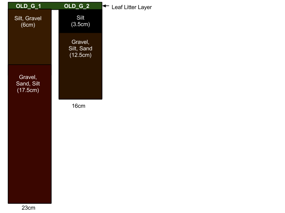
Figure 3: Soil profiles on Old lava flow.
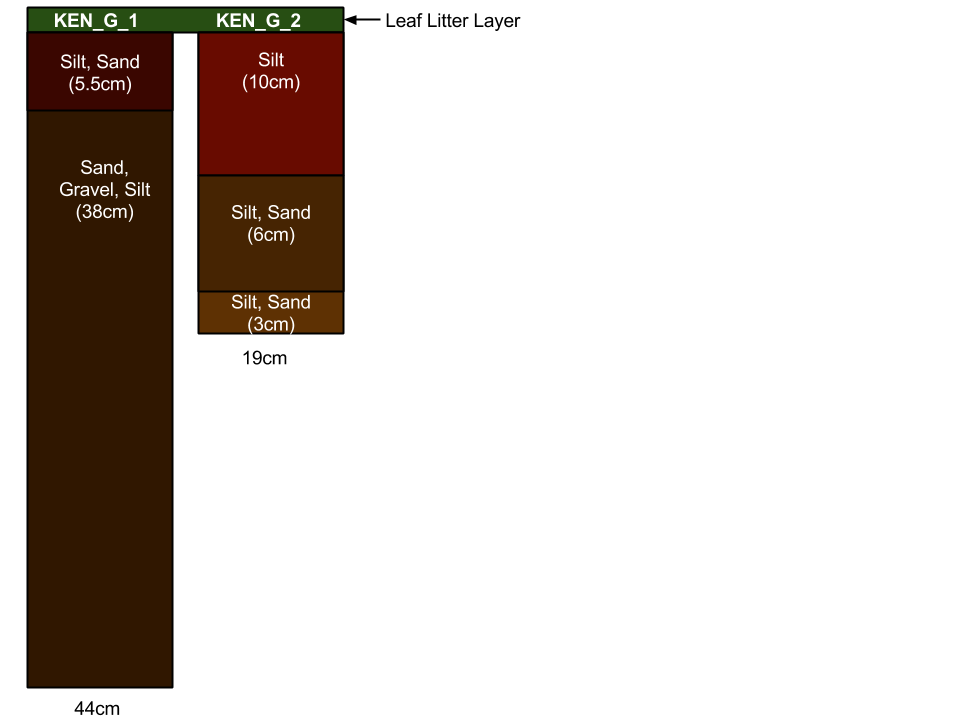
Figure 4: Soil profiles on Kenmarubi lava flow.
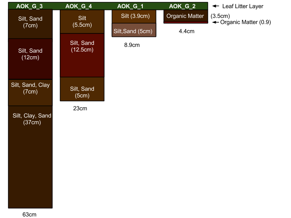
Figure 5: Soil profiles on Aokigahara lava flow.
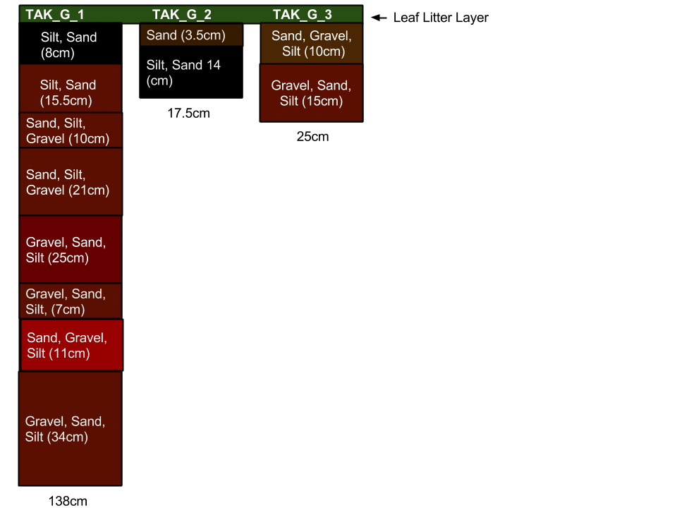
Figure 6: Soil profiles on Takamarubi lava flow.
4 Rock Observations
4.1 Rock Porosity
The highest level of rock porosity was found on the Aokigahara lava flow and the lowest was found at Kenmarubi. Figure 7 depicts approximate rock porosity at each site. As Deligne et. al (2012) suggests, macro porosity and fractures in large rock structures lead to an increased amount of permeability and make it difficult to retain water and support plant life. However, there was no observable difference in the ability for vegetation to grow based on porosity features alone. Each lava flow appeared to have an adequate amount of water, which is most likely due to Japan’s year round rainy climate. Moreover, a number of factors contribute to porosity of rocks including weathering, composition of rock, and the presence of air during the cooling process. Additionally, we found that rocks tended to be relatively less porous and more jagged and a’a-like near the edges of the lava flows. We deduced that this is a result of a more rapid cooling on the edges of the flow.
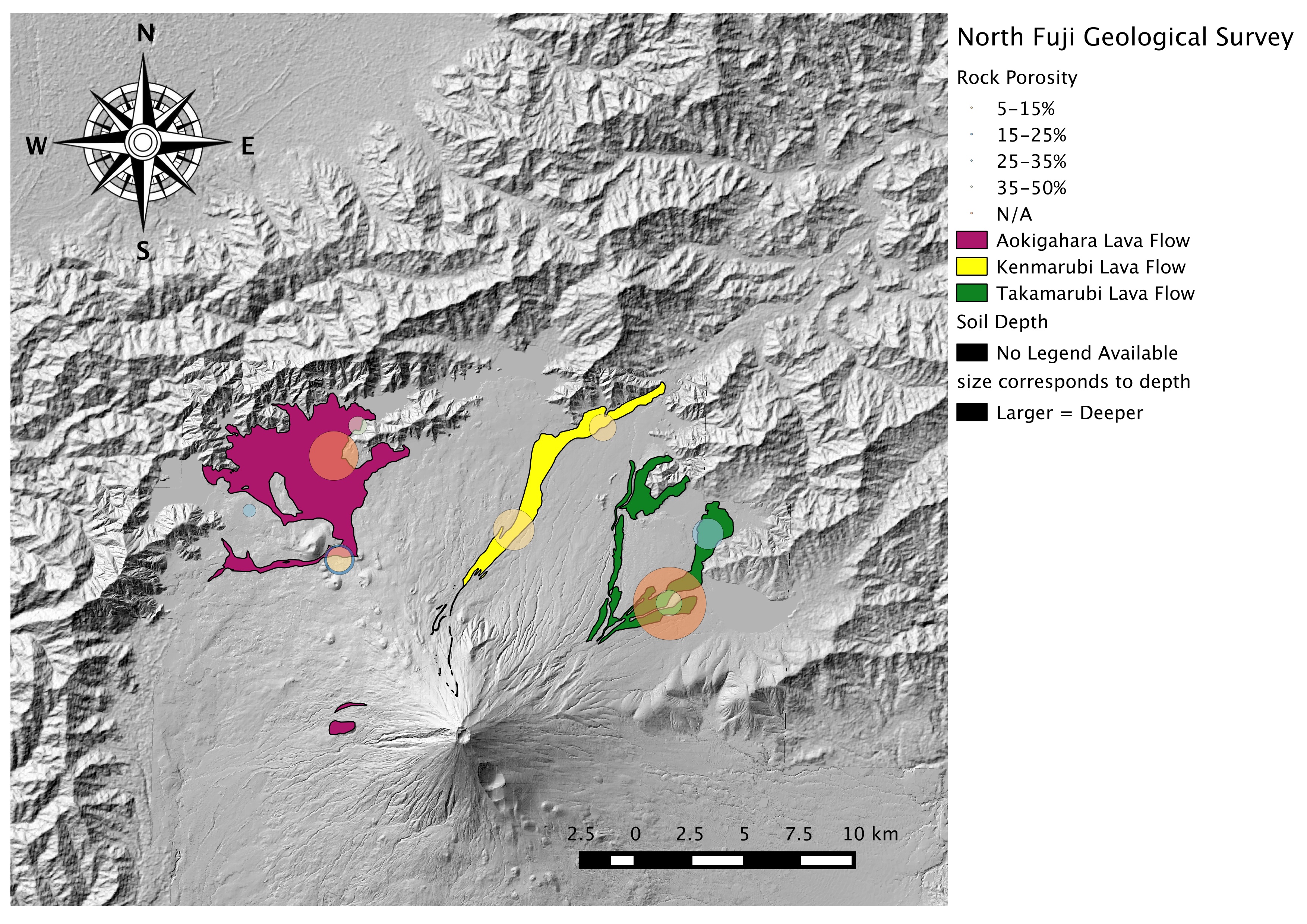
Figure 7. This shows the relationship between macro-porosity and soil over the north Fuji lava flows.
4.2 Rock Color
On all three main sites, Aokigahara, Kenmarubi, and Takamarubi, we observed dark grey to light grey rock color. The weathered rock color was light brown to brown at all of these sites. This indicates that the lava flows occurred relatively closely together on the geologic time scale, and that the composition of the lava flows were similar. The only site where we found a major variation in the rock color was OLD_G_2. At this site, the rock color was black and the color of the weathered rock was light red. This indicates that the lava flow had experienced a greater degree of weathering when compared to the other sites.
5 Macro Feature Observations
5.1 Human Disturbance
We found human disturbance, in one form or another, to be evident at every site we visited. Many of the sites underwent planting, coppicing, and/or harvesting. Some sites were heavily managed for parks and recreation, the forest industry, or both. At KEN_G_2, the lava flow had been cut away to accommodate human development. From these observations we can conclude that none of our observations were of natural growth forests.
5.2 Lava Tree Molds and Lava Tubes
Small, collapsed lava tubes were visible at KEN_G_1. Laying lava tree molds of various sizes were also visible at this site. Similar lava tree molds were also found at AOK_G_1. These lava tree molds indicate that the lava flow knocked down trees but was not hot enough to immediately incinerate the tree. An empty space was formed after the lava cooled around the fallen tree and the tree eventually decayed.
5.3 Lava Flow Edges
During our investigations, we found some key differences between sites on the edges of the lava flow relative to the center of the flow. First, as stated before, the rocks tended to be more jagged and a’a like with a lower level of porosity. This is likely a result of the faster cooling process at the edge of the flow. On these jagged rock structures, less soil was present. Second, in the middle of the flows, the ground tended to be flatter which could indicate a slower cooling rate and a higher flow velocity. Finally, lava tree molds were more prevalent on the edges of lava flows, indicative of lower temperature lava.
6 Botany Observations
We would expect to find a greater degree of vegetation in areas with geological features that are more suitable for plant life. For example, plants prefer deeper soils with moderate permeability that retains enough water and nutrients to support growth. Additionally, we have learned that red pine trees are pioneer species, and we would expect to find these trees dominating rocky areas of the lava flow. Given the data on tree diversity provided to us by the botany group, there is no conclusive evidence that tree species diversity is significantly correlated with the soil and rock features that we observed. However, we did find that none of these areas on the lava flow were used for agriculture, which suggests that the geologic features may have some impact on vegetative land use and land cover, though this observation could also result from site selection bias. Slush flow expert So Anma described one site where agriculture was conducted on the Kenmarubi lava flow, and it was a site where people had actively added substrate to the surface of the lava field to promote plant growth.
7 Conclusion
The geologic data we collected confirmed our understanding of the nature of the Fuji lava flows. After investigating the geologic features of the three major north Fuji lava flows and comparing our findings to the botanical group’s data, we find that there is no recognizable correlation between geology and vegetative land cover. Our observations of the lava flow data by itself, however do show some sort of systemic behavior, although they do not have any observable bearing on vegetation. These findings lead us to conclude that the land cover of these lava flows is dictated both by human activities and land use as well as by geologic factors.
References
Deligne, Natalia I., Katharine V. Cashman, and Joshua J. Roering. 2012. “After the Lava Flow: The Importance of External Soil Sources for Plant Colonization of Recent Lava Flows in the Central Oregon Cascades, USA.” Geomorphology, December. doi:10.1016/j.geomorph.2012.12.009.
Geological Survey Data File (Excel format, multiple sheets):