Much of our time in school is spent studying past material, but in my thesis research, I have to combine both current and historical material to be successful in creating relevant and applicable results. As such, I’ve done a few things this past week, including popular news media analysis, a reflection on my recent “madlibs” exercises, and more GIS spatial analysis.
News & Media Analysis
As I predicted, public land political melodrama surrounds not only the Elliott State Forest but lands across the entirety of Oregon state, the Pacific Northwest, USA, and indeed the world.
Most recent of these controversies surrounds the passing of the so-called Resilient Federal Forests Act of 2017 (H.R.2936, 115th Congress). In one sitting, I managed to read both sides of the arguments surrounding this piece of legislation, which recently passed through Congress and will be under the House scrutiny before long.
Andy Kerr’s breakdown of the legislation is precise… if not a little emotionally charged (which is alright in this context, in my opinion). His basic argument is that the policy is a disguised attempt to open up federal lands for “Big Timber,” a name he uses to describe profit-hungry timber corporations. Kerr is a definitive modern environmentalist, as can be deduced from his website. Still, the arguments he makes are largely valid. The danger of this legislation is that it could destroy the many decades of protection of our federal natural resources.
On the for-side, I watched and analyzed the 3-minute floor speech of Rep. Greg Walden (R-Hood River) who is championing this legislation in Oregon’s Congress. He tries to strike a cord with those in the senate by mentioning the Eagle Creek Fire of this past summer, which burned a massive swath of the Gorge that many Oregonians hold close to their hearts. His main argument clearly outlines the failure of current federal land management policies to create forests resilient to forest fires. My immediate thoughts on Rep. Walden’s case is the inability to accurately convey the depth of the policy with only 3.5 minutes at the floor.
The reason I examined this recent policy development is because of its relevance to O&C Lands in Oregon. If this policy were to pass, the BLM would be mandated to extract at leas 500 mbf in annual timber harvest (according to Kerr, the 2016 maximum harvest was 278 mbf). What does this mean for a potential land swap between the BLM and the Elliott State Forest?
That’s TBD… I’d need to think about the answer over a few rounds of cider & old-fashion’s.
Spatial Analysis
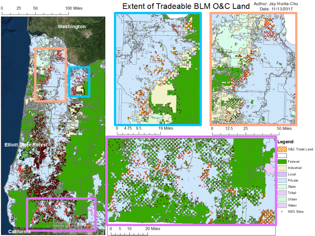
Continuing my work from last week, I examined specifically O&C lands in western Oregon. I roughly outlined the geographic area of BLM-managed O&C lands that could be sold off or traded to the Common School Fund (CSF) in exchange for the Elliott State Forest. As shown in the map below (again, a rough sketch), the tracts of BLM O&C lands are heavily fragmented: at best, they are in an alternating checkerboard patterm, at worst, they are tiny isolated chunks of land. I can’t imagine that the BLM is very effective in managing their often far-out and fragmented pieces of land, and it strikes me as odd especially that these tiny patches still exist as BLM land. Furthermore, a fragmented landscape is less ecologically sound and functional than a contiguous landscape such as a Forest Service wilderness area. Using the Effects tool, I can compare the land ownership layers with the base layers and see some very obvious results of boundary-obsessed land ownership schemes: the boundary between logged areas and conservation areas are so well defined because one side is private while the other is public. The effect of this on the landscape is that forest fragments are scattered across western Oregon’s landscape. It’s clear that a trade of this land for the ESF would allow the CSF to resume timber harvesting activities without critically endangering Northern Spotted Owls. From here, I really need to standardize the method of selecting “tradeable land.”
Reflecting on MadLibs
Over the semester, the ENVS thesis students have completed two “madlibs” exercises that help us condense the immense amount of research we do into a series of simple questions and answers. As I look back, I am, predictably, astounded at the difference between my original madlibs completed over a month ago and my more recent one.
Some initial reactions I have are “Damn, I’m so glad I’m doing the research that I’m doing now, because my old topic seems boring af in comparison” or “I really tackled a huge crazy awesome topic.” My old topic really focused on spatial, scientific and policy research while my new one more on spatial, policy, and economic analysis. My questions are better, my situated context fits seamlessly with my topic, and the current relevancy of my topic is exciting. There are many many more moving parts to my newer research, and I will have to keep this in mind as deadlines are looming just over the horizon.


Leave a Reply