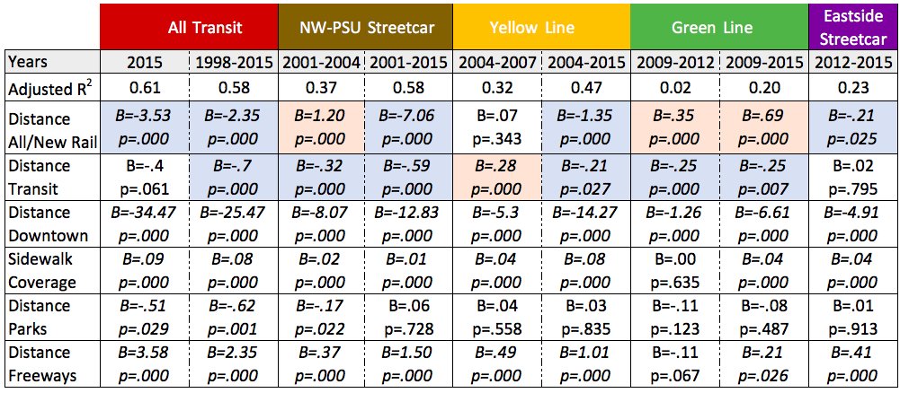
Considering the high interrelation of transit and centrality, I conducted a linear regression analysis to assess transit’s independent effect on land value, both in 2015 and for the 1998-2015 period. Additionally, to analyze how major transit investments have affected land values and potential gentrification, I tested for the statistical significance of proximity to the four major rail capital projects finished during the period 1998-2012. Because the graphed relationship between both transit and centrality and land value appears curvilinear, and the negative values for some of the longitudinal data mean that the logarithm of land value itself can’t be taken, I took the natural logarithm of all of the distance variables. The coefficients in the above table can be divided by 100 to reach the expected change in land value from a 1% change in the variable, holding all other variables constant. Sidewalk coverage is a linear relationship between the percent of streets with sidewalks and land value, meaning that the standardized coefficient reflects the increase in land value from an absolute increase in neighborhood sidewalk coverage of 1%. Statistically significant cases where transit proximity was associated with higher land values/land value appreciation are highlighted in blue, while cases in which it was negatively associated are highlighted in orange.
Downtown proximity was statistically significant in all time periods examined, and sidewalk coverage and proximity to freeways were significant in all but the 2009-2012 period. Holding these variables constant, there were modest statistically significant effects of rail on 2015 land value and of all frequent transit on the 1998-2015 change in value (though not the 2015 value itself). The variegated regressions returned more mixed results. There was a statistically significant relationship between land value appreciation between 2001 and 2015 for the NW-PSU streetcar, between 2004 and 2015 for the Yellow line (through N. Portland) and between 2012 and 2015 for the central eastside streetcar. The Green line, meanwhile, running alongside I-205 in East Portland, was negatively and statistically significantly associated with changes in land value.