In one of our final lab sessions as the Spring 2017 GEOL 340 Problems in Spatial Science class, we utilized MATLAB software to analyze a dataset containing global cloud cover data. The dataset was produced by atmospheric scientist Jennifer Kay of the Nationer Center for Atmospheric Research and Colorado State University. Kay combined radar and LIDAR data collected by Cloudsat and Calipso, two of the satellites that orbit over earth’s poles and cover nearly the entire surface of the earth every day. Using this meaty dataset, each of us students posed a question and attempted to answer it.
The questions I looked at was Does the tropopause change in height seasonally?
First, let’s define exactly what a tropopause is. The tropopause is the interface or boundary separating the troposphere and the stratosphere, which contains the ozone layer. Notice that in the following diagram, the x-y axes are Temperature and Height respectively and that the temperature seems to oscillate depending on which layer of the atmosphere it is in.

Fig. 1: A cross-section of the atmosphere showing varying temperature from the Troposphere to the Thermosphere. Source
Our area of interest is in clouds, and clouds can be roughly split into 3 categories: those at low (0-3km), mid (3-7km), and high (7+km) elevations. Because we are interested in the tropopause, we can narrow our focus to high clouds, a.k.a. clouds that exist at least 7 km above the earth’s surface. By assuming that high clouds in the atmosphere is a rough equivalent to the height or ‘thickness’ of the tropopause, we can observe the behavior of the tropopause seasonally and across different latitudes. This is what the following figure, produced in MATLAB, shows.
Fig. 2: Cloud heights as a function of Latitude. Note that the Hadley Circulation Cells can be seen at near-equator latitudes. These cells are shown in darker hues of blue, which represents an absence of clouds. This logical observation results from the dry (and therefore relatively cloudless) air that exists in arid areas from ~10-40 degrees N/S. The four graphs represent the four seasons. Three-letter abbreviations represent the months of each season.
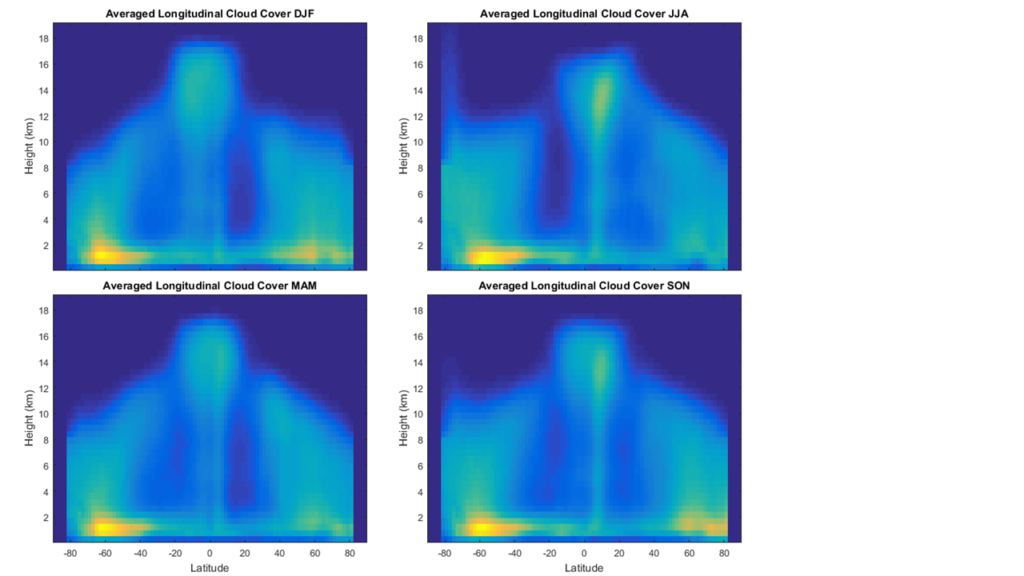
Fig. 2: Cloud heights as a function of Latitude. Note that the Hadley Circulation Cells can be seen at near-equator latitudes. These cells are shown in darker hues of blue, which represents an absence of clouds. This logical observation results from the dry (and therefore relatively cloudless) air that exists in arid areas from ~10-40 degrees N/S. The four graphs represent the four seasons. Three-letter abbreviations represent the months of each season.
One can immediately see that the tropopause is higher at the equator than at the poles. This is likely the case because of the tropical climate existent at equatorial latitudes; the warmer tropical air is less dense, and expand to fill a taller column of air. The colder polar regions have more dense air, and thus a lower tropopause height. The tropopause also seems to vary seasonally. In the summer (JJA), the tropopause is higher at the north pole than at the south pole, and this trend reverses in the winter (DJF). This is likely due to the higher solar radiation reaching the northern hemisphere during the months of June, July, and August and the southern hemisphere during December, January, and February. Solar radiation can heat the earth’s surface and contribute to cloud formation in various ways.


Na saída da barreira brasileira, contudo bastante além disso apressado
se aproveitar passaporte brasileiro. http://passaporteitaliano.info/vantagens-do-passaporte-italiano/